Managing the lakes
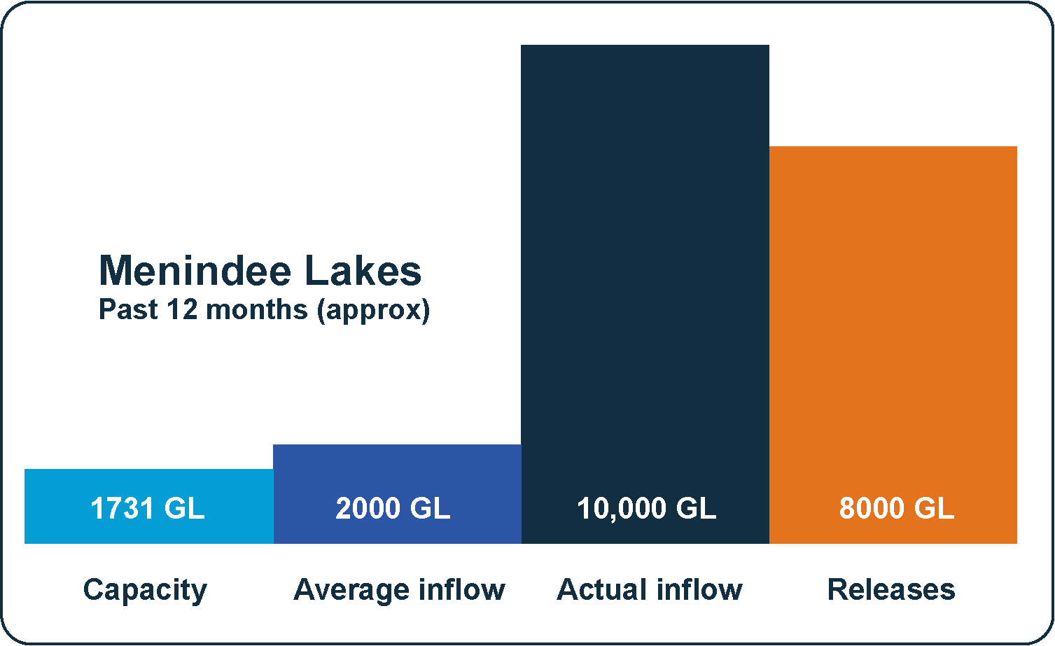
Like many areas of NSW bearing the brunt of wet La Nina conditions, the Menindee Lakes system has received an unprecedented amount of floodwater in the past 12 months.
Over that period the Lakes have received around 10,000 gigalitres of water – six times their capacity and more than five times what they would normally receive in a year.
For the past year WaterNSW has been working hard to protect the community from flooding as much as possible, and we feel for the local people whose lives have been affected.
With a major flood peak arriving in Menindee in December, WaterNSW has been managing the Lakes to continuing flood operations.
While huge volumes of water continue to enter the Lakes, floodwaters have started receding.
WaterNSW’s operations remain focussed on protecting our storages, maximising the water resource and mitigating downstream flooding.
Learn more in our community update

Questions and Answers
Information correct as of 25 January 2023
Was the December 2022 flood forecast?
- Yes – those floodwaters have come from rain and flooding that occurred across the northern Murray-Darling basin in the final months of 2022 that has since made its way down the Barwon-Darling river system.
- From October 2022, WaterNSW, the State Emergency Service and the Bureau of Meteorology have issued notifications about incoming floodwaters from October through operational updates, announcements, public meetings and community information.
Why was the magnitude of the December 2022 bigger than forecast?
- The scale and complexity of this event has made accurate forecasts difficult, particularly when flows branch out and flow across the wide, flat floodplains.
- As a general rule of thumb what can be expected in the Menindee Lakes typically follows the same pattern as the experience upstream at Wilcannia in the main channel.
- In December, Wilcannia experienced floods of approximately 45GL per day however, by the time these flows reached the Lakes they had almost doubled in volume.
- These waters had broken out across the floodplain and were returning from the floodplain via the Talyawalka Creek and re-joined the main channel of the Darling River upstream of the lakes. This was particularly unusual as these floodwaters would typically rejoin the main channel downstream, bypassing the lakes. During this unique event large volumes offloodwater flowed into the Menindee lakes instead.
Do the gauges work and is the modelling adequate?
- WaterNSW uses in situ gauges as well as real-time manual gauging of flood waters.
- This includes two gauges upstream of the Menindee Lakes near Wilcannia - on the Barwon Darling and the Talyawalka. These gauges are joint venture assets, managed in partnership with the Murray Darling Basin Authority.
- These gauges are complemented by in-field manual readings taken by our local water monitoring crews.
- In December, our local water monitoring crews identified significant volumes of water bypassing the main channel and Talyawalka Creek. This resulted in WaterNSW notifying the SES and BoM to help inform their decisions about community safety.
Could WaterNSW have released more water before the December event?
- Despite constantly releasing water all year and creating an air space buffer (300 gigalitres, or more than 17% of the lakes storage capacity) the flood levels in late December were so large they couldn’t all be contained.
- To have captured all of the flows from the December flood, the Menindee storages would have needed to be lowered byaround 50% or more.
- To make such releases would have been impossible without large scale floods.
- WaterNSW is also bound by strict regulatory rules that govern how releases are made. Under these rules, WaterNSW must operate the Lakes to ensure the safety of the asset structure, maintain water security and then, where possible, lessen downstream flooding impacts.
What are the constraints associated with operating the Menindee Lakes during a flood event?
- WaterNSW can typically capture reasonable flows during a flood, if there is enough airspace, however at certain levels water can’t be captured and stored and will be passed as floodwater downstream. To do otherwise under flood operations could risk damage to the dam structures.
- For Menindee system, this results in operating the lakes and assets within tight parameters, to make sure as to:
- Not over-fill the lakes, risking structural damage,
- Avoid inundation of cultural heritage sites, and
- Where possible lesson impacts of flooding on people and property
- This is done while trying to minimise the releases out of Menindee Lakes and keep the flood level in Menindee town as low as possible.
- All increases to water releases are also subject to agreement with the SES.
- This strategy, endorsed by the Local Emergency Management Committee, has ultimately meant that the BoM’s forecast flood peak of 10.7m did not eventuate for the December 2022 flood.
Why doesn’t WaterNSW use Lake Tandou to store water?
- WaterNSW does not own or operate Lake Tandou. It is privately-owned, and so is not a part of the WaterNSW lakes or system.
Why hasn’t WaterNSW used Lake Cawndilla for more storage?
- Lake Cawndilla has been used all year, with the storage full or above-full for much of the past 12 months.
- During the current, December 2022 flooding event, the Cawndilla outlet has been open and releasing the maximum rate however, in mid-January damaging erosion was detected by WaterNSW at Packers Crossing downstream of Lake Cawndilla. To mitigate further damage the outlet was closed for a brief period of time to alleviate this erosion and remedial works undertaken
- The situation is being aggravated by flows downstream at Tandou Creek, causing water to back up into the affected area.
Could Cawndilla outlet have been used more?
- The Cawndilla outlet can only release~2 gigalitres per day (2 GL/day), a small volume that is comparable to the combined daily summer evaporation rate from lakes Cawndilla and Menindee.
- While Cawndilla outlet has been used continually throughout 2022 and into 2023, by far the greatest volume of water released from the lakes has been into the Darling River via a number of outlets and the main weir.
Was the community warned about impending floods?
- WaterNSW regularly releases information about its dam operations. In October the community began receiving notifications about incoming floodwaters expected to arrive in December/January through operational updates, announcements, public meetings and community information provided by the SES, WaterNSW and the Bureau of Meteorology.
- During flood events WaterNSW works closely with the State Emergency Service (SES) and the Bureau of Meteorology (BoM).
- The SES is the lead combat agency, responsible for front-line response to emergencies and for letting the community know if they need to prepare to evacuate and managing evacuation operations.
- The BoM is responsible for providing information to community and response agencies on river heights and flood warnings for the community. They do the forecasting using information from a number of sources, streamflow gauge information and their own modelling.
Will WaterNSW protect sacred Aboriginal sites and artefacts at Lake Cawndilla?
- WaterNSW is working to protect these sites and artefacts, operating Lake Cawndilla to ensure the storage does not exceed the maximum dam safety limit, where they would be inundated.
Where can I find more data from Menindee Lakes operations?
- Historical and current information can be found at Water Insights: https://waterinsights.waternsw.com.au/lowerdarling
Related links
WaterNSW acknowledges the traditional custodians of the lands and waters on which we work and pay our respects to all elders past, present and emerging. Learn more